


COLBY - T 1 Voting District, Clark County, Wisconsin
About
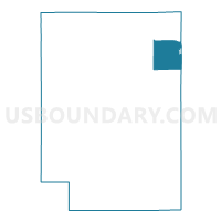
Outline

Summary
| Unique Area Identifier | 692764 |
| Name | COLBY - T 1 Voting District |
| County | Clark County |
| State | Wisconsin |
| Area (square miles) | 33.77 |
| Land Area (square miles) | 33.75 |
| Water Area (square miles) | 0.02 |
| % of Land Area | 99.94 |
| % of Water Area | 0.06 |
| Latitude of the Internal Point | 44.89527610 |
| Longtitude of the Internal Point | -90.38048850 |
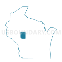
Maps

Graphs
Select a template below for downloading or customizing gragh for COLBY - T 1 Voting District, Clark County, Wisconsin


Neighbors
Neighoring Voting District (by Name) Neighboring Voting District on the Map
- Abbotsford - C 1 Voting District, Marathon County, WI
- Abbotsford - C 2 Voting District, Clark County, WI
- Abbotsford - C 4 Voting District, Clark County, WI
- BEAVER - T 1 Voting District, Clark County, WI
- Colby - C 1 Voting District, Marathon County, WI
- Colby - C 1 Voting District, Clark County, WI
- Colby - C 2 Voting District, Clark County, WI
- Colby - C 4 Voting District, Clark County, WI
- Curtiss - V 1 Voting District, Clark County, WI
- GREEN GROVE - T 1 Voting District, Clark County, WI
- HULL - T 1 Voting District, Marathon County, WI
- MAYVILLE - T 2 Voting District, Clark County, WI
- UNITY - T 1 Voting District, Clark County, WI
- Unity - V 1 Voting District, Marathon County, WI
- Unity - V 1 Voting District, Clark County, WI
Top 10 Neighboring County Subdivision (by Population) Neighboring County Subdivision on the Map
- Abbotsford city, Clark County, WI (1,616)
- Colby city, Clark County, WI (1,354)
- Mayville town, Clark County, WI (961)
- Beaver town, Clark County, WI (885)
- Unity town, Clark County, WI (878)
- Colby town, Clark County, WI (874)
- Hoard town, Clark County, WI (841)
- Green Grove town, Clark County, WI (756)
- Hull town, Marathon County, WI (750)
- Abbotsford city, Marathon County, WI (694)
Top 10 Neighboring Place (by Population) Neighboring Place on the Map
- Abbotsford city, WI (2,310)
- Colby city, WI (1,852)
- Unity village, WI (343)
- Curtiss village, WI (216)
Top 10 Neighboring Unified School District (by Population) Neighboring Unified School District on the Map
- Colby School District, WI (7,014)
- Owen-Withee School District, WI (4,608)
- Loyal School District, WI (4,037)
- Abbotsford School District, WI (3,698)
Top 10 Neighboring State Legislative District Lower Chamber (by Population) Neighboring State Legislative District Lower Chamber on the Map
Top 10 Neighboring State Legislative District Upper Chamber (by Population) Neighboring State Legislative District Upper Chamber on the Map
Top 10 Neighboring 111th Congressional District (by Population) Neighboring 111th Congressional District on the Map
Top 10 Neighboring Census Tract (by Population) Neighboring Census Tract on the Map
- Census Tract 21, Marathon County, WI (7,190)
- Census Tract 9505, Clark County, WI (5,277)
- Census Tract 9501, Clark County, WI (4,950)
- Census Tract 9502, Clark County, WI (4,520)
- Census Tract 22, Marathon County, WI (3,490)